A moose near Jackson Lake Junction.
|

Some land forms near the northwest corner of the Wind River Indian Reservation. |

Crowheart Butte.... |
|

Fort Washakie from the north side of town...
The entry from my book for April 29, 1882: "Third Cavalry soldiers and Indian scouts fought a group of Indians near Fort Washakie, Wyoming. According to army documents, one soldier and one Indian were killed."
|
|

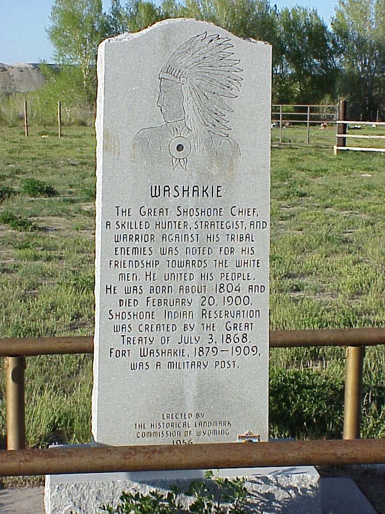
Chief Washakie's grave on the west side of Fort Washakie.
The entry from my book for July 3, 1868: "The Fort Bridger Treaty (15 Stat. 673) created the Wind River Reservation for the Shoshone and Arapaho Tribes. It covered 2,828 square miles of Wyoming and was occupied by the Northern Arapaho and Eastern Shoshone." Click here to go to the Eastern Shoshone Tribe website |

Chief Washakie, 1870.
Credit to wyomingtalesandtrails.com
This is the headquarters for the Shoshone (also spelled Shoshoni, and a few other ways) who live on this reservation. The tribal headquarters was closed, and I could not find the library. The "learning center" was open, so I went in. I asked them where the local library was (I wanted to give them a copy of my book). The young woman there told me to turn right at the stop sign and go south until I saw the sign. I had just gone that way while I was looking for the tribal headquarters and I did not see a sign. I asked her if she meant the highway. She said yes. I asked her how far down the road the library was. She said about 30 miles. In reality, the library was in the town of Lander. Before I left town, I visited the grave of Chief Washakie.
|
|

Southwest of town is the Sacajawea cemetary
|

The story is that a local historian talked the minister into saying these were their graves.
The entry from my book: "A woman, identified by local missionaries as Sacajawea, died in Wyoming. If this was the Sacajawea of the Lewis and Clark expedition, she would be almost 100 years old."
|

Many years later (1945?) Rev. Roberts recanted, and said that he had buried and old woman and it was historian Grace Raymond Hebard who said it was Sacajawea and her children.
|

Rose Ann Abrahamson, her great-great-great-grandniece, told me that she probably died near Fort Manuel Lisa in South Dakota when she was 24. |

This is a headstone marker in the same cemetery on the Shoshoni reservation.
|

I did not get a chance to take a picture of the beautiful church in Fort Washakie. |

These three pictures where taken by Gwen. |

This is a very nicely designed place. I wish I had seen it.
|

In Landers, Wyoming, the Popo Agie River diappears into a cave in the Sinks Canyon park. |

At one time the river flowed completely on the surface. |

This sign explains that the rive flows underground for a few hundred yards. |

This is the pool where the river comes back to the surface. It is called "the Rise." |

Some of the large fish in the pool. Fishing is prohibited in this area. |

More of the river as it flows away from the pool. |

More explanations...
|