| Spokane Plains Battlefield |
Steptoe Battlefield |
Snake River |
Lewiston-Clarkston |
| Nez Perce Reservation |
Cottonwood Battlefield |
Whitebird Battlefield |
Clearwater Battlefield |
| Kamiah-
"Heart of the Monster" |
Weippe |
Lolo Trail |
Lolo Pass |
| Big Hole Battlefield |
Lemhi Pass |
Camas Meadows Battlefield |
Yellowstone National Park |
| Grand Tetons |
Wind River Indian Reservation |
Sinks Canyon |
Legend Rock |
| Medicine Lodge Archaeological site |
Conners Battlefield |
Wagon Box Battlefield |
Rosebud Battlefield |
| Two Moons monument |
Little Bighorn Battlefield |
Fetterman Battlefield |
Fort Phil Keany |
| Crazy Woman Creek Battlefield |
Fort Reno |
Dull Knife Battlefield |
Ayers Natural Bridge |
| Fort Fetterman |
Fort Laramie |
Grattan Battlefield |
Hudson-Meng Bison Bonebed |
| Warbonnet Monument |
Crazy Horse Monument |
Devil's Tower |
Rapid City |
| Pine Ridge Reservation |
Wounded Knee |
Badlands National Park |
Cheyenne River Reservation |
| Standing Rock Reservation |
Fort Berthold Reservation |
Fort Peck Reservation |
Fort Belknap Reservation |
| Bear Paw Battlefield |
Fort Assiniboine |
Blackfeet Reservation |
30 meters into Canada |
| Glacier National Park |
Flathead Reservation |
Missoula |
and a few others... |
I landed in Spokane, Washington on the 17th. No less than 10 minutes out of the airport, I was driving through snow and icy rain. What a change for a southern boy! I visited the Spokane Plains Battlefield (which has a marker on the site, but not on the highway) and the Steptoe Battlefield. Steptoe is in the tiny town of Rosalia. From there I drove down to the Snake River and followed it into Lewiston, Idaho.

This is the plaque on the battlefield just west of Spokane, Washington.
This is the entry from my book for this incident: "Colonel George Wright, commanding the local army, fought with Coeur d’Alene, Columbia River, Colville, Kalispel, and Spokane Indians on the Spokane Plains. The army defeated the Indians."
|

There were no signs on the road, but the marker was pretty big. It was raining when I took this picture. |

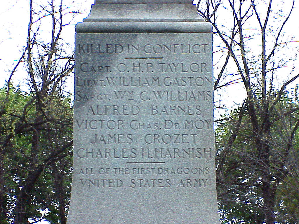
The Steptoe battlefield is south of Spokane in the little town of Rosalie.
|

Details of the sign.
This is the entry from my book: "The battle against E. J. Steptoe and his troops began and ended disastrously for Steptoe. The battlefield became known afterward as Steptoe Butte. Brevet Lieutenant Colonel Steptoe had organized an expedition from Fort Walla Walla in southeastern Washington into the Coleville country to seek out hostiles. With 158 soldiers and thirty civilian volunteers, Steptoe encountered hundreds of Spokane and Coeur d’Alene Indians. Steptoe retreated and fought a running battle. Many lives were lost on both sides. The battle was fought about thirty miles south of present-day Spokane." |

This is the Steptoe battlefield marker.
|

Details from the marker.
|

More details..........
|

..........even more..........
|

Another marker at the Steptoe battfield
|

A final view with that interesting old bridge in the background. |

This is the Snake River Canyon southwest of Pullman, Washington.
|

More of the Snake River, just before Clarkston.
|

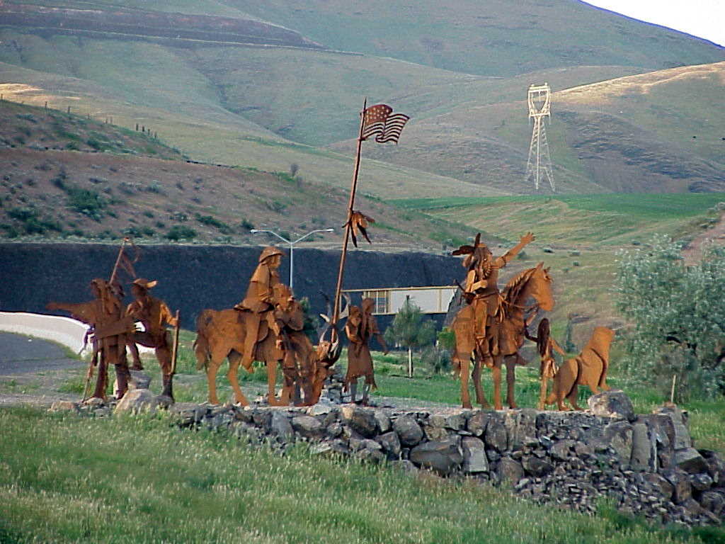
Some metal sculptures in Lewiston, Idaho, just before you enter the Nez Perce reservation.
|

The sign says: "Entering Nez Perce Indian Reservation"
Here I entered the Nez Perce reservation. Their name for themselves is Nee-me-poo. It was a beautiful area. The recent rains had left everything moist and verdant. |

There is a museum here in Spalding, Idaho. |

There are lots of descriptive signs in Idaho.
Click here to see a National Park Service (NPS) website about Coyote's Fishnet.The sign says: "A Nez Perce Indian legend tells how Coyote and Black Bear had a falling out while fishing here long ago. Coyote, the all-powerful animal spirit, was having a good time until Black Bear, the busybody, began to tease him. Finally, losing his temper, Coyote tossed his huge fishnet onto the hills across the river. To teach Black Bear a lesson, Coyote threw him to the top of the hill on his side and turned him to stone. The Nez Perce people know just where to look for the net and unfortunate bear." |

Since the mission was only "near here," I didn't take a picture of the countryside.
The entry from my book: "Five years earlier, several Nez Perce traveled to St. Louis to ask for someone to come to their land to teach them about religion. In response to that request, missionary Henry Harmon Spalding traveled to Idaho. He set up a mission today on some land (twelve miles south of modern Lewiston) given to him by the Nez Perce." |

This is very lush and beautiful country. A National Park brochure says: "William Craig, a mountain man, interpreter, a friend of the Nez Perce and husband of a Nez Perce woman, was the only white person to have official permission from the Nez Perce to live on the reservation.
"
|

The sign says: "When he came to Lewiston in 1867, Father J.M. Cataldo developed a Jesuit Nez Perce mission that continued long after he founded Gonzaga University in Spokane. A chapel was built a mile up Mission Creek in 1868, but a permanent location was not established until construction of Saint Joseph's Mission was completed at a more secluded site in 1874. It now is open to visitors as part of the Nez Perce National Historical Park."
Click here for a NPS site on the mission. |

Another great railroad bridge not far from Lapwai. |

This sign is for the Cottonwood battlefield. It was after sunset. With all of the snow clouds, I could not get a good picture of the area. The sign says: "A Gatling gun, firing from the top of a low hill a mile northwest of here, beat off a Nez Perce attack, July 4, 1877. The next day, Indians just east of here surrounded 17 Mount Idaho volunteers: two were killed and three wounded before cavalrymen from Cottonwood came out to rescue them. Meanwhile, Chief Joseph's people, screened this well-planned diversionary skirmish, crossed the prairie to join their allies on the Clearwater. From there the Indians retired across the mountains to Montana, where the Nez Perce War ended three months later."
This is the entry from my book: "For the next two days, the Nez Perce engaged in several skirmishes with the local settlers and the army in the Camas Prairie area of Idaho north of Tolo Lake and Grangeville. Almost two dozen whites were killed in the fighting."
Click here for the NPS site on Cottonwood.
Click here for a detailed NPS site about the battle
|

There are Lewis & Clark signs all over this part of Idaho. This one says: "On May 31, 1806, Sgt. John Ordway and Pvts. Frazer and Weiser were dispatched from Camp Chopunnish (Kamiah) to Lewis's River (Snake River) to obtain salmon. Guided by Nez Perce Indians, the men crossed the Camas Prairie near here. On May 29, at a Salmon River Indian village, Frazer traded an old razer to an Indian woman for two Spanish mill dollars. They reached the Snake River after descending the worst hills we ever saw a road make down. They were welcomed by Nez Perce and purchased a number of salmon."
This is the start of the bicentennial of their expedition. All of the quotes from their journal are from "The History of the Lewis and Clark Expedition," edited by Elliott Coues. |